Networks, GIS and Linked Data
Maximilian Schich (School of Arts and Humanities, The University of Texas at Dallas)
Topography and Topology: Towards common ground in archaeological research
Topographic space has been a dominant paradigm in archaeology for more than five centuries, ever since practitioners started to systematically document ancient remains in ground plans, elevations, perspectives, and maps. In the digital age, topographic records are accelerating exponentially, from simple lists of toponyms to sophisticated compounds, resulting in a multiplicity of opinion that is hard to reconcile into a single coherent picture with three spatial dimensions and one clear evolution over time. Instead we are confronted with a much more complex, multidimensional, hard to understand and frequently incoherent topological space of similarities, implicit dependencies, and relations to other dimensions, such as the social and conceptual.
This talk explores how the science of complex networks, computer science, physics and information design can help us better appreciate regularities and local deviations in this multidimensional topology.
Alex Godden (Economy, Transport and Environment Department, Hampshire County Council)
Historic Environment Records: New ways of looking for the past
Historic Environment Records (HERs) represent unique repositories of information relating to sites, finds, buildings and landscapes that illustrate human activity from c. 500,000 BC to the present day. Inputting these data into Geographic Information Systems and online platforms can enable spatial analysis and greater sharing opportunities. As such, the contents of HERs have the potential to enrich museum collections and archives, underpin historic environment planning decisions and land management advice, contribute to research, and enhance public knowledge.
This paper suggests possible developments for HERs to attract new audiences and partnerships with other heritage organisations in the public, private and academic sectors, which can ensure that HERs remain a critical hub informing heritage work for the future.
Alex’s talk Alex’s slides
John Goodwin (Ordnance Survey)
Ordnance Survey and Linked Data
In April 2010 a number of Ordnance Survey’s datasets were made open, in both a linked data and the more traditional GIS format. Since support at this time for spatial indexing and querying in linked data technologies was still immature, the decision was made to explicitly encode the spatial relationships between geographic regions. This talk outlines how an ontology was built to describe these spatial relations and the attempt to capture their semantics using the Web Ontology Language. In particular it considers the current GeoSPARQL standard from OGC, illustrating the use of this qualitative spatial approach with examples from the OS dataset.
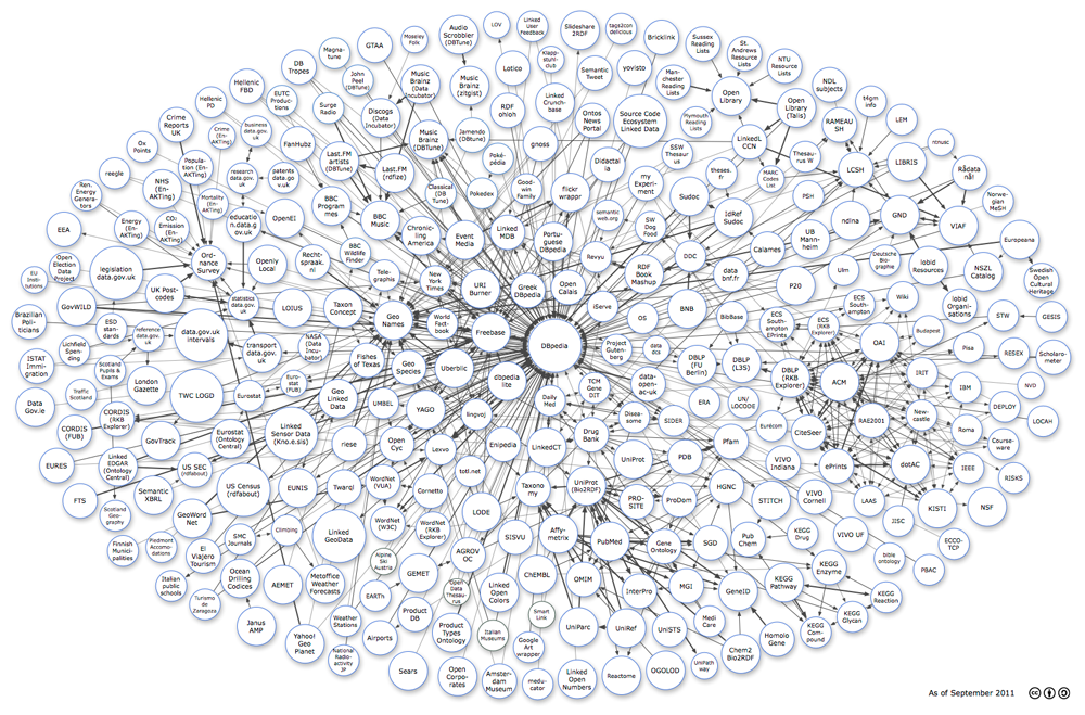
The diagram is maintained by Richard Cyganiak (DERI, NUI Galway) and Anja Jentzsch (HPI). For any questions and comments, please email richard@cyganiak.de andmail@anjajentzsch.de.