visualisation

Palladio: Humanities thinking about data visualization

palladio_logo

A guest post by Mark Braude, Postdoctoral Research Fellow / Project coordinator, Humanities + Design, Center for Spatial and Textual Analysis (CESTA), Stanford

An Overview of Palladio

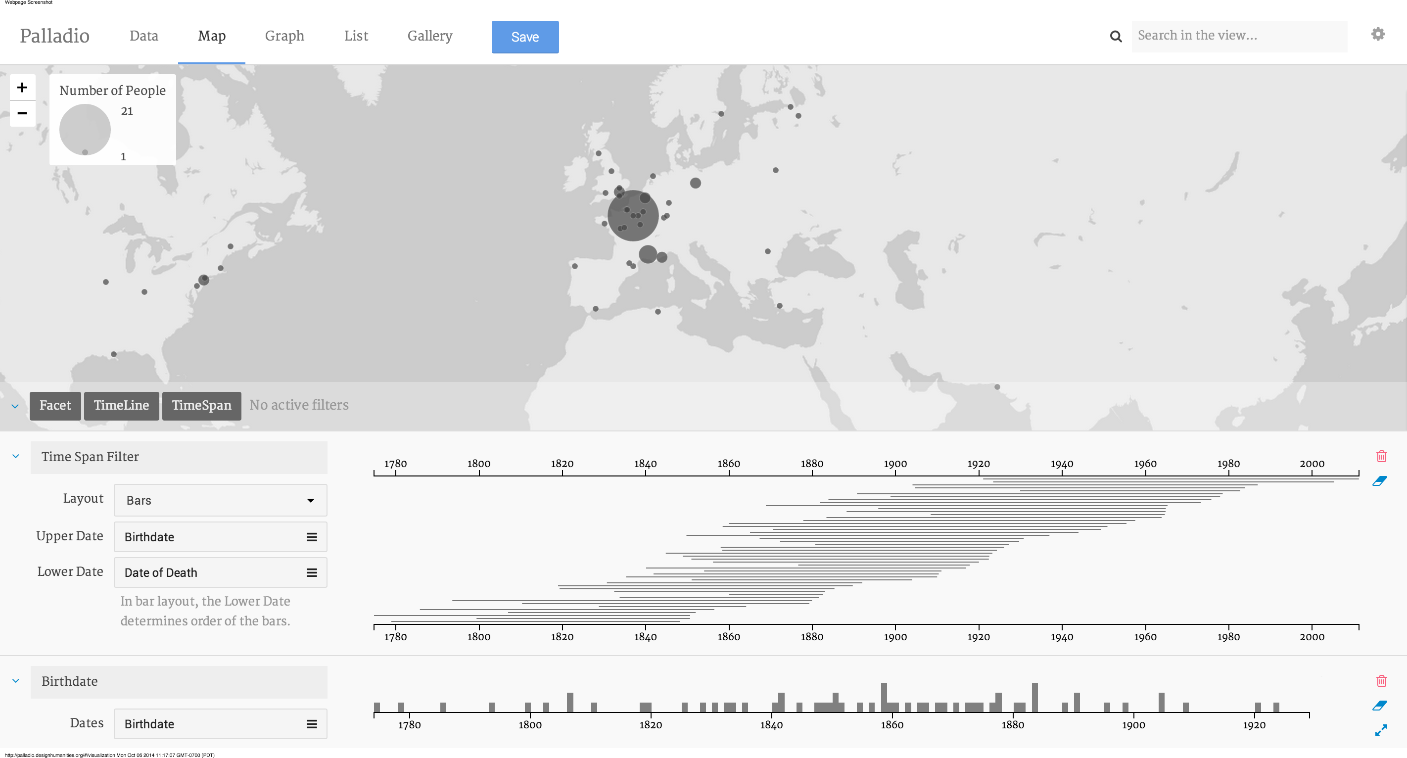
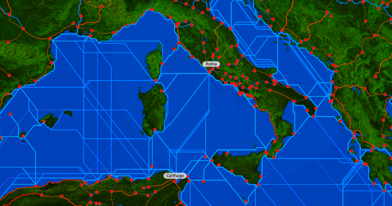
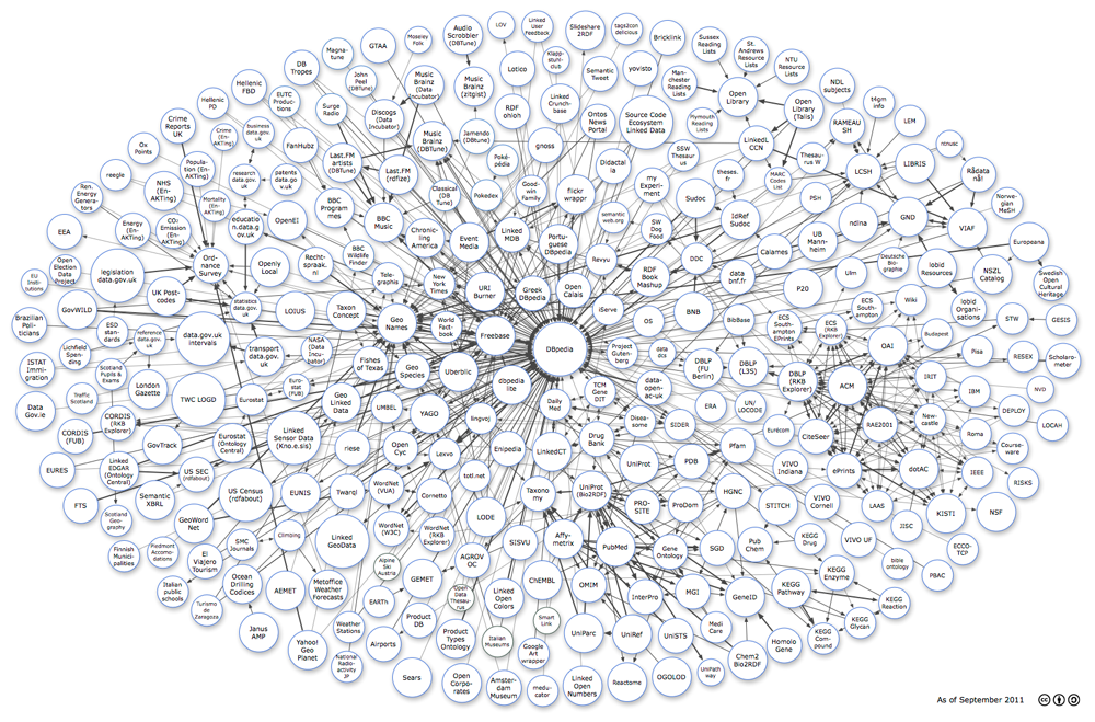
Palladio (palladio.designhumanities.org) is a web-based platform that allows any researcher to upload, visualize, and analyze complex and multi-dimensional data, directly in a web browser. The Palladio visualization system combines a primary view with filters to make it easy to query a data set. There is no need to create an account and nor do we store any data. Any work done in the browser can be saved and shared as a Palladio Project, which takes the form of a .json file.

Read More»

Beyond images and surfaces: Impressions from the ‘Telling stories with maps’ symposium in Birmingham

As we have already written on this blog, the fourth event within the Hestia 2 programme recently took place in Birmingham. With its focus on qualitative GIS and narrative mapping, this symposium was closest to my own academic interests and motivations for participating in the project. Its selection of papers, audience and topics achieved one of the long-standing aims of the Hestia team: to bring together the social sciences, humanities and the ‘IT crowd’ in a genuine interdisciplinary dialogue. Testifying to the success of the event were the high attendance rate, the diverse professional backgrounds of participants, and the numerous follow up discussions instigated on different fora (particularly twitter and the ‘blogosphere’).

Read More»

Why Update ORBIS?

There’s a lot of digital humanities left to be done. There are books that haven’t been digitized that need to be mined to find trends to put on maps using algorithms that haven’t even been designed yet. So, when you consider that the significant effort necessary to put a new finish on a project like ORBIS, you might think it’s a waste of time. I know I get a bit uncomfortable about it when I consider the other projects that were proposed and which lost out on achieving some measure of implementation because of the support for a version 2 of ORBIS. It’s not a zero sum game that we have going in this field, but it does suffer from entrenchment and there are natural inducements to supporting existing, successful work that can foster a rich-get-richer climate.

Read More»

Topotime: A data model and D3 layout for historical time

I was pleased to participate in the Hestia2@Stanford event held December 4-5, 2013 at Stanford’s Center for Spatial and Textual Studies (CESTA). The program, titled Visualizing Complex Networks,  included several researchers from Stanford as well as a couple of digital humanities initiatives in nearby San Francisco. The plan was to share progress and prospects for some local projects that “explore network analysis and uncertainty in data from a number of different perspectives,” touching on topics and methodologies related to the Hestia project.

Read More»

Networks, visualizations, and the space-time conundrum

Back in November Hestia2 held its second seminar in a place where the sun really does always shine (see below): Stanford, California. There was a very good reason, in addition to being able to wear a t-shirt in November, for holding a seminar on Digital Humanities in Stanford. With its campus in Palo Alto, Stanford shares a location with a number of high-tech household names, including Apple, Google and Facebook, while smaller start-ups in the San Francisco Bay Area are but a short Caltrain ride away. One of these, Farallon Geographics, has recently worked with the Getty Conservation Institute and World Monuments Fund, to produce an open-source, web-based, geospatial information system for cultural heritage inventory and management, called Arches, showing the massive potential for collaboration between private digital enterprise and the public cultural sector, including higher education.

Read More»

Hestia2@Stanford: Visualizing Complex Networks

The Center for Spatial and Textual Analysis is proud to host the next Hestia2 event, on November 4-5 in Wallenberg Hall at Stanford University. During this free one and a half day seminar we will explore network analysis and uncertainty in data from a number of different perspectives. It will also be an opportunity to take a sneak preview of a number of new and exciting projects.

Read More»

Tools and Platforms

Kate Byrne (University of Edinburgh)

Geoparsing and spatial network analysis in the GAP projects

This talk describes the spatial analysis of textual resources based on the results of two phases of a Google-funded project: Google Ancient Places (GAP) establishes the means of discovering and visualizing ancient place-names in texts, while the Geographic Annotation Platform (GAP2) extends the data capture to any text.

Read More»

Networks, GIS and Linked Data

Maximilian Schich (School of Arts and Humanities, The University of Texas at Dallas)

Topography and Topology: Towards common ground in archaeological research

Topographic space has been a dominant paradigm in archaeology for more than five centuries, ever since practitioners started to systematically document ancient remains in ground plans, elevations, perspectives, and maps. In the digital age, topographic records are accelerating exponentially, from simple lists of toponyms to sophisticated compounds, resulting in a multiplicity of opinion that is hard to reconcile into a single coherent picture with three spatial dimensions and one clear evolution over time. Instead we are confronted with a much more complex, multidimensional, hard to understand and frequently incoherent topological space of similarities, implicit dependencies, and relations to other dimensions, such as the social and conceptual.

This talk explores how the science of complex networks, computer science, physics and information design can help us better appreciate regularities and local deviations in this multidimensional topology.

Maximilian’s talk

Read More»

A Seminar on Approaches to Geospatial Analysis

A report on the Hestia2 seminar in Southampton, 18 July 2013

Spatial relationships appear throughout our sources about the past: from the ancient roads that connect cities, or the political alliances between places identified by ancient authors, to the stratigraphic contexts archaeologists deal with in their fieldwork. Of course, spatial relationships are also important in contemporary documents and have a key role to play in urban planning and cultural heritage management. However, as the digital medium is increasingly used in recording information, datasets have become increasingly large, making spatial relationships ever more difficult to disentangle. The challenge is particularly acute when trying to extract spatial relationships from texts.

Read More»

Announcing Hestia Phase 2

Hestia2 is a public engagement project aimed at introducing a series of conceptual and practical innovations to the spatial reading and visualisation of texts. Following on from the AHRC-funded “Network, Relation, Flow: Imaginations of Space in Herodotus’s Histories” (October 2008 – July 2010), Hestia2 represents a deliberate shift from experimenting with geospatial analysis of a single text to making Hestia’s outcomes available to new audiences and widely applicable to other texts through a seminar series, online platform, blog and learning materials with the purpose of fostering knowledge exchange between researchers and non-academics, and generating public interest and engagement in this field. You can read more about the new phase here.