Use-cases in Archaeology and English Heritage

Keith May (English Heritage)

Exploring the Use of Semantic Technologies for Cross-Search of Archaeological Grey Literature and Data

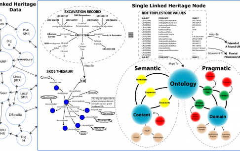
Work has been ongoing at English Heritage in the use and development of the CIDOC CRM ontology for modelling the archaeological processes, data and conceptual relationships involved in excavation recording and analysis. This modelling has been used to bring together a range of different archaeological datasets – originating from a number of separate organisations – so that they could be cross-searched using semantic technologies. This level of interoperability for otherwise unintegrated data is itself a valuable step. Further work in the Semantic Technologies for Archaeological Resources (STAR) project explored the possibilities of mapping elements of descriptive free text to the Conceptual Reference Model and thereby making aspects of the archaeological reports cross-searchable too, alongside the other datasets.

Read More»

Tools and Platforms

Kate Byrne (University of Edinburgh)

Geoparsing and spatial network analysis in the GAP projects

This talk describes the spatial analysis of textual resources based on the results of two phases of a Google-funded project: Google Ancient Places (GAP) establishes the means of discovering and visualizing ancient place-names in texts, while the Geographic Annotation Platform (GAP2) extends the data capture to any text.

Read More»

Networks, GIS and Linked Data

Maximilian Schich (School of Arts and Humanities, The University of Texas at Dallas)

Topography and Topology: Towards common ground in archaeological research

Topographic space has been a dominant paradigm in archaeology for more than five centuries, ever since practitioners started to systematically document ancient remains in ground plans, elevations, perspectives, and maps. In the digital age, topographic records are accelerating exponentially, from simple lists of toponyms to sophisticated compounds, resulting in a multiplicity of opinion that is hard to reconcile into a single coherent picture with three spatial dimensions and one clear evolution over time. Instead we are confronted with a much more complex, multidimensional, hard to understand and frequently incoherent topological space of similarities, implicit dependencies, and relations to other dimensions, such as the social and conceptual.

This talk explores how the science of complex networks, computer science, physics and information design can help us better appreciate regularities and local deviations in this multidimensional topology.

Maximilian’s talk

Read More»

A Seminar on Approaches to Geospatial Analysis

A report on the Hestia2 seminar in Southampton, 18 July 2013

Spatial relationships appear throughout our sources about the past: from the ancient roads that connect cities, or the political alliances between places identified by ancient authors, to the stratigraphic contexts archaeologists deal with in their fieldwork. Of course, spatial relationships are also important in contemporary documents and have a key role to play in urban planning and cultural heritage management. However, as the digital medium is increasingly used in recording information, datasets have become increasingly large, making spatial relationships ever more difficult to disentangle. The challenge is particularly acute when trying to extract spatial relationships from texts.

Read More»

Workshop Trials

Teaching ancient history can be difficult. You are dealing with what can seem a remote and lofty world which has little in common with ours, very often you are dealing in abstracts or people who at first glance have little in common with us. This is not true but it is a perception.

I remember someone once saying to be that seeing a temple for real helps it make sense. It is one of those things which always stuck in my head and resonated when I thought about my own experiences of travelling ancients sites.

Ok, so what we are talking about here is not quite the same as actually seeing something for real, but it is pretty close.

Read More»

Announcing Hestia Phase 2

Hestia2 is a public engagement project aimed at introducing a series of conceptual and practical innovations to the spatial reading and visualisation of texts. Following on from the AHRC-funded “Network, Relation, Flow: Imaginations of Space in Herodotus’s Histories” (October 2008 – July 2010), Hestia2 represents a deliberate shift from experimenting with geospatial analysis of a single text to making Hestia’s outcomes available to new audiences and widely applicable to other texts through a seminar series, online platform, blog and learning materials with the purpose of fostering knowledge exchange between researchers and non-academics, and generating public interest and engagement in this field. You can read more about the new phase here.